

You can find your Louisiana flood zone for free in about five minutes by entering your address into FEMA's Flood Map Service Center. The map you'll see is your FIRM (Flood Insurance Rate Map), and the zone letter it shows — X, A, AE, or V — tells you your flood risk and whether coverage is federally required. Once you can read those letters, your flood map stops being mysterious and starts telling you what coverage will cost and why.

Your flood zone sounds like bureaucratic mystery, but it's really just a code you can look up in about five minutes — and once you can read it, the letters stop being intimidating and start telling you what coverage will cost. In a state as flood-prone as Louisiana, knowing your zone is one of the most useful things you can do for your home. This guide explains what a flood map is, how to find your zone by address, what each zone letter means, why base flood elevation matters, and what to do if you think your zone is wrong. The team at The Root Agency, serving Central and the greater Baton Rouge area, can pull and interpret your map from our Baton Rouge office.
Key takeaways
- Look up your flood zone free by address at FEMA's Flood Map Service Center (msc.fema.gov).
- A FIRM is FEMA's official Flood Insurance Rate Map showing your area's flood risk.
- Zones starting with A or V are high-risk; Zone X is moderate-to-low risk.
- Base flood elevation (BFE) is the height floodwater is expected to reach — a key driver of your premium.
- If you think your zone is wrong, you can request a Letter of Map Amendment (LOMA).
What is a Flood Insurance Rate Map (FIRM)?
A FIRM is FEMA's official map of flood risk for your community. It shows which areas face higher or lower flood hazard, marks the high-risk Special Flood Hazard Areas, and assigns each area a flood zone designation used to price flood insurance and trigger requirements.
Think of it as the reference document behind a lot of flood decisions: whether your lender requires coverage, how your area's risk is classified, and where the base flood elevation applies. FIRMs are maintained by FEMA and available to anyone. In the Baton Rouge area, they reflect proximity to systems like the Amite, Comite, and Mississippi — which is why homes just a few streets apart can carry different designations.
How do you look up your flood zone by address?
It takes about five minutes and costs nothing. Use FEMA's Flood Map Service Center:
- Go to FEMA's Flood Map Service Center at msc.fema.gov.
- Enter your full property address in the search box.
- View the dynamic map or open the official FIRM for your area.
- Find your property and read the flood zone label covering it (for example, X, A, AE, or V).
- Note whether you fall inside a Special Flood Hazard Area (the high-risk A and V zones).
If the map is hard to interpret — and they can be — a local agent can pull it and read it for you. The team at The Root Agency does this routinely, so you don't have to guess whether that shading covers your lot. New to the state? Our guide to Louisiana insurance requirements for new residents pairs well with a zone lookup.
What does each flood zone letter mean for you?
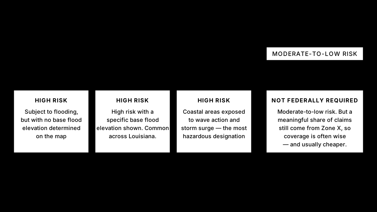
The letter is a shorthand for your risk level and your requirements. Here's what the common Louisiana designations mean:
- Zone X — moderate-to-low risk. Flood insurance isn't federally required here, but a meaningful share of claims still come from Zone X, so coverage is often wise and usually cheaper.
- Zone A — high-risk, subject to flooding, but without a detailed base flood elevation determined on the map.
- Zone AE — high-risk with a specific base flood elevation shown. Common across Louisiana river and rainfall flood areas.
- Zone V — high-risk coastal areas exposed to wave action and storm surge, the most hazardous designation.
If your home sits in an A, AE, or V zone and you have a federally backed mortgage, expect the mandatory purchase requirement to apply. If you're in Zone X, you're not required to carry it — but “not required” isn't “not needed” in Louisiana.
What is base flood elevation, and why does it drive your premium?
Base flood elevation (BFE) is the height floodwater is expected to reach during the “base flood” — an event with a 1% chance of happening in any year. On AE zones, it's shown as a specific elevation on the map.
BFE matters because your premium and your risk both hinge on how your home sits relative to it. A first floor above the BFE faces less flood risk and generally costs less to insure; a first floor below it faces more risk and higher premiums. Even under Risk Rating 2.0, which prices each home individually, your first-floor height relative to flood risk remains one of the biggest factors in your rate — which is why elevation and mitigation can genuinely lower your cost.
What if you think your flood zone is wrong?
You can challenge it — flood maps aren't infallible. If you believe your property was mapped into a high-risk zone by mistake (for example, your lot is on higher ground than the map reflects), you can request a Letter of Map Amendment (LOMA) from FEMA.
A successful LOMA can remove the federal flood-insurance requirement on a structure that's actually above the base flood elevation, which can save you money. The process usually involves elevation documentation, and it's worth pursuing if you have reason to think your home was mapped too aggressively. A local agent can point you to the right FEMA process and help you understand whether a LOMA is likely to succeed for your property. For the bigger cost picture, our guide to why insurance is so expensive in Louisiana adds useful context.
Want help reading your flood map?
Flood maps can be confusing, but you don't have to interpret yours alone. The team at The Root Agency can pull your FIRM, tell you exactly what your zone means for requirements and cost, and quote NFIP coverage for your home. When you're ready, start on our flood insurance page or contact your Central-area team, and we'll read the map with you.
This article is general information, not insurance advice. Flood zones and requirements depend on your specific property — verify with FEMA and talk with a licensed agent about your coverage.